通过GeoServer发布GanosBase中的栅格数据。
添加数据源
不同的GeoServer版本,打开的GeoServer Web Portal可能存在差异,本文以GeoServer 2.23.2为例。
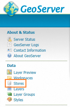
打开GeoServer Web Portal,选择Stores。

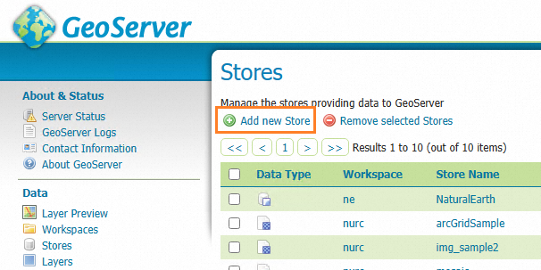
单击Add new Store。

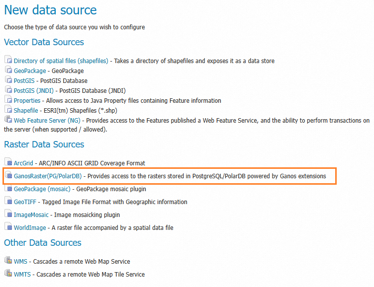
选择GanosRaster(PG/PolarDB)。

填写GanosBase数据库的连接信息。
参数名称
描述
示例
host
数据库地址(IP或RDS连接地址)。
xxxxxxx.pg.rds.aliyuncs.com
port
数据库端口号。
3432
database
数据库名称。
rasterdb
username
数据库用户名。
pguser
password
数据库密码。
123456
schema
表所在的schema。
默认为public
table
栅格所在表名。
raster_table
column name
栅格列名称。
raster_column
filter
栅格对象过滤条件,为SQL语句中的where条件。 如果符合条件的栅格有多个,总是使用第一个。
id=1或name='srtm'
name
geoserver显示的栅格名称。
myraster
REST API
创建数据源
接口:http://host:port/geoserver/rest/workspaces/{workspace}/coveragestores
方法:POST
参数:
workspace:已经创建好的workspace名称。
datastore body:示例如下,其中type为固定写法,url中填写阿里云PG/PolarDB的连接参数(JSON格式)。
{
  "coverageStore": {
    "name": "<datasource_name>",
    "type": "GanosRaster(PG/PolarDB)",
    "enabled":"true",
    "workspace":"<wokrspace>",
    "url": "{\"column\":\"<raster_column>\",\"database\":\"<database_name>\",\"filter\":\"<raster_filter>\",\"host\":\"<pg_host>\",\"name\":\"<public_name>\",\"password\":\"<user_password>\",\"port\":<pg_port>,\"schema\":\"<schema_name>\",\"ssl\":false,\"table\":\"<raster_table_name>\",\"userName\":\"<user_name>\",\"valid\":true}"
  }
}
创建数据源示例
{
  "coverageStore": {
    "name": "srtm",
    "type": "GanosRaster(PG/PolarDB)",
    "enabled":"true",
    "workspace":"test",
    "url": "{\"column\":\"rast\",\"database\":\"test_db\",\"filter\":\"name='srtm'\",\"host\":\"pgm-xxxxxxxx.pg.rds.aliyuncs.com\",\"name\":\"srtm_image\",\"password\":\"xxxx\",\"port\":3432,\"schema\":\"public\",\"ssl\":true,\"table\":\"raster_table\",\"userName\":\"raster_user\",\"valid\":true}"
  }
}
获取数据源
发布栅格图层
接口:http://host:port/geoserver/rest/workspaces/{workspace}/coveragestores/{store}/coverages
方法:POST
参数:
workspace:已经创建好的workspace名称。
post的body格式如下:
{
  "coverage": {
    "abstract": "Digital elevation model for the Spearfish region.\r\n\r\nsfdem is a Tagged Image File Format with Geographic information",
    "defaultInterpolationMethod": "nearest neighbor",
    "description": "Generated from sfdem",
    "dimensions": {
      "coverageDimension": [
        {
          "description": "GridSampleDimension[-9.999999933815813E36,-9.999999933815813E36]",
          "name": "GRAY_INDEX",
          "range": {
            "max": -9.999999933815813e+36,
            "min": -9.999999933815813e+36
          }
        }
      ]
    },
    "enabled": true,
    "grid": {
      "@dimension": "2",
      "crs": "EPSG:26713",
      "range": {
        "high": "634 477",
        "low": "0 0"
      },
      "transform": {
        "scaleX": 30,
        "scaleY": -30,
        "shearX": 0,
        "shearY": 0,
        "translateX": 589995,
        "translateY": 4927995
      }
    },
    "interpolationMethods": {
      "string": [
        "nearest neighbor",
        "bilinear",
        "bicubic"
      ]
    },
    "keywords": {
      "string": [
        "WCS",
        "sfdem",
        "sfdem",
        "type\\@language=fr\\;\\@vocabulary=test\\;"
      ]
    },
    "latLonBoundingBox": {
      "crs": "EPSG:4326",
      "maxx": -103.62940739432703,
      "maxy": 44.5016011535299,
      "minx": -103.87108701853181,
      "miny": 44.370187074132616
    },
    "metadata": {
      "entry": [
        {
          "@key": "elevation",
          "dimensionInfo": {
            "enabled": false
          }
        },
        {
          "$": "10",
          "@key": "cacheAgeMax"
        },
        {
          "@key": "time",
          "dimensionInfo": {
            "defaultValue": "",
            "enabled": false
          }
        },
        {
          "$": "true",
          "@key": "cachingEnabled"
        },
        {
          "$": "sfdem_sfdem",
          "@key": "dirName"
        }
      ]
    },
    "name": "sfdem",
    "namespace": {
      "href": "http://localhost:8075/geoserver/restng/namespaces/sf.json",
      "name": "sf"
    },
    "nativeBoundingBox": {
      "crs": {
        "$": "EPSG:26713",
        "@class": "projected"
      },
      "maxx": 609000,
      "maxy": 4928010,
      "minx": 589980,
      "miny": 4913700
    },
    "nativeCRS": {
      "$": "PROJCS[\"NAD27 / UTM zone 13N\", \n  GEOGCS[\"NAD27\", \n    DATUM[\"North American Datum 1927\", \n      SPHEROID[\"Clarke 1866\", 6378206.4, 294.9786982138982, AUTHORITY[\"EPSG\",\"7008\"]], \n      TOWGS84[2.478, 149.752, 197.726, 0.526, -0.498, 0.501, 0.685], \n      AUTHORITY[\"EPSG\",\"6267\"]], \n    PRIMEM[\"Greenwich\", 0.0, AUTHORITY[\"EPSG\",\"8901\"]], \n    UNIT[\"degree\", 0.017453292519943295], \n    AXIS[\"Geodetic longitude\", EAST], \n    AXIS[\"Geodetic latitude\", NORTH], \n    AUTHORITY[\"EPSG\",\"4267\"]], \n  PROJECTION[\"Transverse_Mercator\", AUTHORITY[\"EPSG\",\"9807\"]], \n  PARAMETER[\"central_meridian\", -105.0], \n  PARAMETER[\"latitude_of_origin\", 0.0], \n  PARAMETER[\"scale_factor\", 0.9996], \n  PARAMETER[\"false_easting\", 500000.0], \n  PARAMETER[\"false_northing\", 0.0], \n  UNIT[\"m\", 1.0], \n  AXIS[\"Easting\", EAST], \n  AXIS[\"Northing\", NORTH], \n  AUTHORITY[\"EPSG\",\"26713\"]]",
      "@class": "projected"
    },
    "nativeFormat": "GeoTIFF",
    "nativeName": "sfdem",
    "requestSRS": {
      "string": [
        "EPSG:26713"
      ]
    },
    "responseSRS": {
      "string": [
        "EPSG:26713"
      ]
    },
    "srs": "EPSG:26713",
    "store": {
      "@class": "coverageStore",
      "href": "http://localhost:8075/geoserver/restng/workspaces/sf/coveragestores/sfdem.json",
      "name": "sf:sfdem"
    },
    "supportedFormats": {
      "string": [
        "ARCGRID",
        "IMAGEMOSAIC",
        "GTOPO30",
        "GEOTIFF",
        "GIF",
        "PNG",
        "JPEG",
        "TIFF"
      ]
    },
    "title": "Spearfish elevation"
  }
}